 |
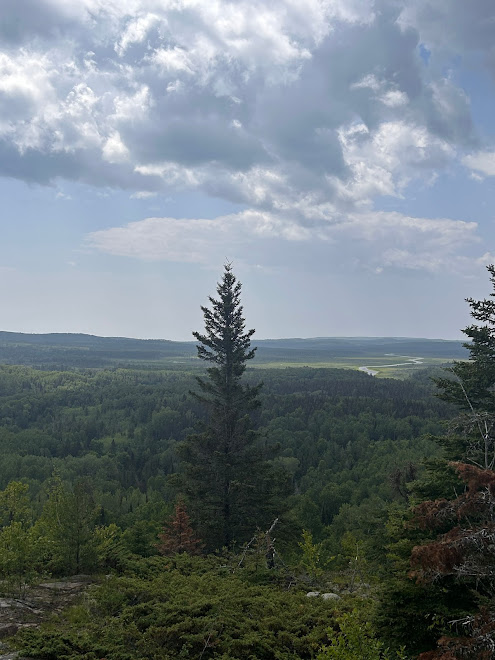
| The 270 Degree Overlook |
Thousands of tired, nerve-shaken, over-civilized people are beginning to find out that going to the mountains is going home; that wildness is a necessity." John MuirIn July, I finished my first NOBO section hike through sections F and E of the Superior Hiking Trail (SHT). And I’ve started planning for my next trip to meet and complete a couple more sections.
I'm a rookie, but now that I've been there I know more about the trail. I hiked two northern sections, climbed around on its rocks and boulders, slept on its dirt and through its storms, ate its fruit, smelled its aroma and absorbed its atmosphere through its, often, remote natural areas.
The SHT is a 298 (or 310, I’ve read both) mile foot trail of moderate difficulty. I found it to be a good one for a first time solo backpacker.
Trail development began in the 1980’s, making this a relatively newly developed trail - as trails go, with active management and maintenance coming through the Superior Hiking Trail Association (SHTA) and their force of volunteers.
The SHTA is very active and offers great resources that go a long way in making a Through- (310 mi), Traditional- (260 mi) or Section-hike (whatever you make it), trip work well.
Beginning south of Duluth, it travels with an easterly bent until about mile 250 where it takes a more northerly direction., terminating at the 270 Degree Overlook, also known as the Northern Terminus. This is about 35 miles northwest of Grand Marais, and a few miles south of the Pigeon River which is the natural US/Canadian border. It passes through 7 state parks, has frequent road crossings, offers 94 free primitive campsites, each with at least one fire ring, rustic benches, a vault toilet and tent pad sites. The campsites come in 3 sizes: small (2-3 pads), medium (4-6) and large (6+) and are near water sources or near an original water source.
No permit or submitted itinerary is required. for this trail. What is required is campsite camping. Disperse and stealth camping are not allowed as much of the land the trail passes through is private land. Quite frankly, unless you're a hammock user, it'd be tough finding a flat place to pitch a tent anywhere along this trail, except for trailheads and alongside a remote dirt road somewhere (which aren't allowed).
This area is in the most southern reaches of the forest biome known as the Boreal forest so you hike through an interesting mix of jack-, red-, and white pine, quaking aspen, paper birch, species of Northern hardwoods, balsam fir, black spruce, and some white cedar. There may be others, but this is what I saw when my eyes weren't fixed on the 18-20 in. wide trail as i tired to avoid tripping on the next root or rock. I'm estimating this trail to be a Class 2, which makes it technical enough to keep it interesting.
The SHT showcases numerous inland lakes, dynamic rivers, quiet little streams, bogs and wetlands, gorges that take your breath away, deafening waterfalls and a 1.5 mile hike along the rocky Lake Superior shoreline.
Navigating is easy with the frequent blue blazes for main trail and white for spurs, confirmation SHT logos are often tacked on trees near the blazes, and there are signs at trail heads with mileages to campsites, trailheads and points of interest imprinted and painted in blue.
The trail's divided into 6 main sections (A-F), each approximately 50 miles in length and each having 6-7 subsections.
The trail basically follows the ridges, gorges and valleys of the Sawtooth Mountain Range on the North Shore of MN. Ascents and descents are nearly continuous (cue the "Sawtooth"). Seldom is there a flat section, although there are a few. With each flat there's usually a price to pay; and that payment comes in the form of another big climb or elevation change of some sort.
The area is ripe with flora, fungi and fauna. I section hiked sections F and E in the month of July and found I could pretty much eat my way down the trail with Thimbleberries, Blueberries, Service Berries and Gooseberries leading the way.
Varieties of mushrooms and all sorts of lichen and algae are often seen along the trial.
This is a 300 mile trail-bouquet of wildflowers, some common throughout the upper midwest and others unique to the area.. July, when nearly everything is in full bloom, makes this place a visual feast.
The permanent/local residents you'll probably not see, but you might see evidence of them. It's reported the North Shore is home to moose, black bear, fox, white tailed deer, martin and mink, wolves and coyote, beavers and a variety of other small rodents (some who'll boldly scold you for setting your tent up under their favorite red pine). I saw a lot of moose and bear scat, suspected but very old wolf scat, heard a pack of really happy and satisfied coyotes one night, and saw just the tail of a white tailed deer as it booked its way through the forest. And rodents. - red squirrels and chipmunks That's it. I did carry bear spray but never came close to taking it out. The SHTA is a strong promoter and supporter of Leave No Trace (LNT) which is most likely why so few animals, especially bear and rodents have not become habitualized to humans.
I had some highlights from my first solo section hike: 1) sleeping alone in the woods, (surrounded by whatever lives there year round) in the kind of dark where there's no refection of light and listening to the "as still as stone" quiet; 2) meeting hikers on trail and feeling an instant bond and connectedness with each one, feeling like I'll know them forever in a special partnership; and 3) allowing a level of self-sustained confidence to emerge, showing me I can still do hard things.
I hope to be back next year to pick up where I left off and to
"HIKE THAT SHT".


Comments
Post a Comment